Late Spring 2015

Some of our RCI points
were expiring during June. If we wanted to get some use out of the points
generated by the Verde Ridge property, we would have to use them before the end
of the month. We had already discussed a trip to Glacier this summer but this seemed
like a possibility. Checking with RCI online we found that there actually was
an RCI resort near West Glacier so we signed up for a week. After the fact, I
checked with GNP and found that they were still working on clearing the
Going-to-the-Sun Highway and the earliest that it would be open was mid-June.
Uh-oh. Hopefully there would be things to do that would not require a trip
across the park! At that point we didn’t know if we should bring snowshoes and
skis or hiking gear. It wasn’t until we were almost ready to leave that GNP
posted a video on Facebook showing a drive along the road to Many Glacier and
there was no snow except on the high peaks. Okay, so we would take boots and
trekking poles…and our sea kayak. There were some long, narrow, fjord-like
lakes on the west side of the park that might be fun to paddle.
22 May, Fri – We got up earlier than usual in order to get
on the road around 0700 for the 500 mile drive to West Glacier. My rule of
thumb is that we average 50 mph on every long trip so it would take ten hours,
putting us in at 1700 for check-in. We didn’t get going until 0720 and then
realized that C.J. was lacking a rain jacket and pants. With a little use of
mobile data we figured out that we could hit the REI in Spokane and take advantage
of its spring sale for some new rain gear. C.J. also found a new, lightweight
daypack on sale. Next we stopped in Coeur d’Alene for gas at Costco ($2.499,
much cheaper than the
 |
| Glacier Wilderness Resort cabin |
$2.839 at the Iss. Costco). In addition to those two
stops, we had to undergo two boat inspections – one in Idaho and one in Montana
[Plus there was a self-certification process for the kayak at GNP, as well.]
All those delays put us close to 1830 by the time we pulled into Glacier
Wilderness Resort. New owner/manager (?) Christy checked us in and then sent us
on a short hike to see the waterfall just a few hundred yards upstream. We paid
for our cleaning fee ($25) and for wifi ($15) which is only on during the day.
Back at our nicely appointed two bedroom log cabin, C.J. whipped up a pasta,
ham and pesto dinner.
23 May, Sat of Memorial Day weekend – Up around 0700 and out
by 0850, we drove the eight-plus miles to the West Glacier/Apgar entrance to
GNP. Our plan was to do the Avalanche Lake hike, an
 |
| C.J., Avalanche L Tr. |
easy five-mile round trip
with only 500 ft of elevation gain. We drove the fifteen miles or so along Lake
McDonald and McDonald Creek to the trailhead…and the end of the
Going-to-the-Sun highway. We weren’t prepared for the crowd of bikers who
filled the parking lots on both sides of the road. They were going to bike up
the now-cleared road as far as Logan Pass; some were carrying skis, intending
to climb up to some good spring-skiing. There were plenty of hikers as well for
the Avalanche Lake Trail, not quite a steady stream but we were rarely out of
sight of one group or another. The first 0.4 mi were on the boardwalks or
pavement of the Trail of the Cedars nature trail, then we started climbing
alongside the gorge of Avalanche Creek. The trail was mostly in the forest but at one point a large landslide from a mountainside to the north had smashed through the trees and opened up a view.
 |
| Results of avalanche |
When we reached the lake the views were
excellent, but the crowd of people lounging around the outlet end of the lake
detracted somewhat from the wilderness ambiance. After taking a few photos, we
continued around the lake to the far end, about 0.5 mi. There we found a log on
the beach near one of the inlets, a good place for a scenic lunch break without
the crowds (and without the plague of chipmunks) at the other end of the lake.
After some crackers and cheese and a cookie, we headed back along the same
trail. There were, if anything, more people on the trail than there were at ten
or eleven o’clock. Back at the trailhead C.J. and I walked the rest of the
nature trail which had some interpretive signage done as haiku on watercolors.
On the drive back to West Glacier we stopped several times along the cascading
McDonald Creek to walk to various viewpoints (once, a footbridge) for pictures.
Then we skipped McDonald Lodge to go to Apgar Village where we found an ice
cream shop ($6.25) and checked in at the Visitor Center to get info about
kayaking – the ranger thought Bowman was just as good as the farther-in Kintla
Lake, and that the p.m. wind was down lake (from the NE) (unlike what we
observed around lunchtime at Avalanche Lake). We stopped for gas in West
Glacier (2.599) and then drove back to the resort. The wifi was working and
C.J. was able to check the weather; I downloaded email. Later C.J. roasted a
big chicken, baked a potato and prepared some veggies for dinner.
24 May, Sun – Saturday night we had agreed to hike to the
Apgar Lookout not far from the west entrance. The guidebook said that the sun
would be in our eyes looking toward the scenery east of
 |
| C.J., Tr to Apgar Lookout |
McDonald Lake, so
suggested the climb be made later. That didn’t seem like a good idea
considering the fact that the whole trail was located in the 2003 Roberts Fire
and there was little shade to be had. We got away from the resort by 0915 and
started up the trail at 0945. Unlike the day before, this time we had an
elevation gain of 1800 ft in 3.2 miles. The first mile or so of the trail
climbed along Rubideux Creek through young lodgepole pines no more than 4-5 ft
tall, plus some low alder liberally festooned with tent caterpillars. Once we
reached the first long switchback the slide alder appeared to have been sprayed
as all the leaves were dead. Three switchbacks crossed the entire face of Apgar
and made for a relatively gentle but unrelenting climb. Although there had been
only five cars in the small parking lot at the trailhead, we were passed by
several parties both ascending and descending. We made it to the fire tower
just before 1245 and the view north to the snowy mountains along the
continental divide was excellent. We climbed to the small wrap-around deck of
the tower for the view, somewhat obscured by the broadcast TV tower and the
trees, then returned to the ground to find a place to eat with a reasonable
view. Others arriving after us settled on the deck to eat. We continued to meet
people who were on their way up as we descended although that couldn’t have
been pleasant as the temperature had increased, particularly in the sun. Later
the clouds grew enough to provide some shade. I had not carried enough water
and sucked my Platypus dry before we reached the only water near the trail, not
far from the trailhead. Once back at the now almost full parking lot we headed
for West Glacier where I thought I could get a good mobile phone signal and
contact Consumer Cellular [I have not been able to receive calls for at least
the last two days]. We parked at the West Glacier Mercantile but there was one
bar or none for cell reception. We looked to see what was available in the
Mercantile – not much, and all priced for low supply, high demand. Back at the
resort around 1600 we showered and then tried some of the Blue Moon varieties
we had brought with us, along with some chips and onion dip. C.J. threw a bunch
of sweaty clothes in the washer so we could start fresh on Monday (although the
weather is sounding less promising with rain or thunderstorms in all the
forecasts).
25 May, Mon, Memorial Day – Another beautiful morning so we
got packed up and out by 0900

heading east on US 2 for the other side of the Park. We stopped at Essex to
drive up the hill to see the Izaak Walton Inn, thinking that we might stop
there for dinner someday. Just a short way down Rte 2 we stopped at the Goat
Lick Observatory even though the parking lot entrance was gated. No goats were
licking so we rolled on through increasingly magnificent scenery. We stopped
again at the summit of Marias Pass where there was a replica of the Washington
Monument dedicated to Theodore Roosevelt. Heading down the other side we came
to East Glacier

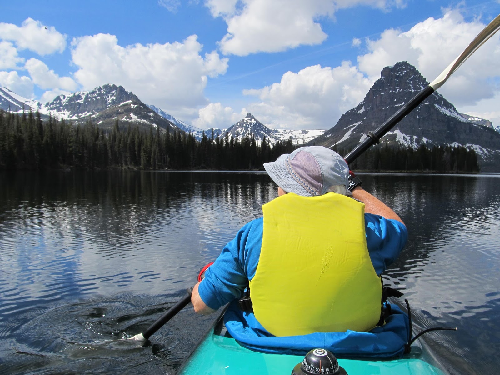
Park and turned north to get to the entrance to the Two
Medicine area of Glacier. We stopped to check conditions at the small Ranger
Station and then drove to the boat launch. The lake looked calm and the sky had
only a few clouds so we quickly set up the kayak and paddled off. We headed for
an obvious point on the south shore, and when we got close C.J. spotted two
moose – a cow with a very young calf. We got some good photos as we drifted by
them. We reached the west end of the lake in about 45 minutes and caught up
with another kayaker who had left just before us but had missed the two moose.
C.J. and I pulled our kayak up in front of the Adirondack-style shelter near
the boat dock and changed shoes for a walk up
the trail about a mile to Twin
Falls. I felt kind of naked without my pack and trekking poles, but I did have
the bear spray
 |
| Young Moose at end of Two Med. Lake |
(which we have carried on all our hikes). Meanwhile the weather
was changing and we heard a couple of rumbles of thunder. There were a few
other folks on the trail who had hiked along one side or the other of the lake
and most were stopping at Twin Falls and then continuing another 1.3 mi to
Upper Two Med Lake. Just as we got back to the shelter, two young moose appeared
across the stream from us. They were too busy stripping the leaves from the
willows to care that we were taking their pictures, and then watching them as
we ate lunch. Eventually they moved off along the trail to Twin Falls, and we
re-launched the kayak and headed downlake with some wind in our faces. Still it
took us only 45 minutes again to reach the boat launch at Two Med. We got some
help lifting the kayak back onto the car then we drove over to the campground
to see what the sites looked like; they were all pull-through, very
 |
| Mtn Sheep in Two Med. Campground |
convenient
for our small trailer, and some had great views of the mountains. Best of all
we encountered a small herd of mountain sheep wandering through the campground,
some even eating whatever was left in a firepit. We made one more stop to hike
0.3 mi to Running Eagle Falls (once known as Trick Falls) which has an upper
stream flowing over the top of the falls and a lower stream coming out of a
large cave. As we left Two Med it started to rain and it rained pretty hard until
we were out of East Glacier and back on US 2. At Marias Pass we stopped to
drive through the USFS Summit CG – all sites suitable for small trailers,
$10/night, about 5200 ft. It was really too early to stop for dinner at Izaak
Walton (1700) so we returned to the resort for some drinks and snacks before a
meal of homemade chicken soup. We discussed plans for the next day and decided
on going to the North Fork area of Glacier and paddle Bowman Lake. We thought a
dawn start would give us the best chance to see critters (but then we found out
that we would have to leave at 0400 to get to the launch by 0544, dawn. We’ll
see if we can get going so early.
26 May, Tue – We woke, as planned, at 0400 and were on the
road before 0500. The Camas Road was paved all the way from Apgar to the North
Fork Road (outside). Surprisingly, about half of the
 |
| Bowman Lake campground and boat launch |
North Fork was paved, too;
maybe it was just the part through privately-owned land. At Polebridge, the
tiny community that is home to the Polebridge Mercantile and Bakery, the road
became not only unpaved but narrow and much rougher. [A sign at the barebones
NPS ranger station at Polebridge explained that the road condition was kept
that way on purpose to keep the area as wilderness-y as possible.] We had no
trouble with the six miles of the Bowman Lake Road but we also felt no need to
exceed the posted 20 mph speed limit. It was about 0615 when we reached the
campground and boat launch, about 30 minutes after sunrise. The lake was still
calm; the air wasn’t too cold but the water was frigid. I switched my
lightweight pants for some fleece and added a layer of fleece under my PFD. The
surrounding mountains were shrouded in fog and clouds and we could see none of
the snow-frosted mountains that would appear later as the
 |
| By 0845 the clouds had lifted |
clouds broke and the
fog burned off. It was probably 0700 by the time we were on the water and
paddling up the north side of the lake. There was one other boat on the water
and a few people in the campground, nothing like the more-accessible Two
Medicine. We stopped for a break after an hour (and about three miles of
paddling) then continued to the end of the lake (a bit more than six miles as
the crow flies) and backtracked to the backpackers’ campground. We rested for a
while and had a snack then headed across the lake and down the south side. C.J.
said her feet got so cold while getting into the boat that they didn’t warm up
for an hour. Eventually the sun broke through and by the time we were making
the last crossing back to the boat launch, we were wishing we had removed at
least one layer of fleece. Back on land around noon; after unloading the boat
we had some lunch in the sunshine and then hit the road for home. We stopped at
the Polebridge Mercantile to get one of their famous pastries ($4.75), and
thought we might go to Columbia Falls to replenish our fresh veggie and fruit
supply. When we reached the Camas Road, though, we stopped to walk the
 |
| Great reflections on a calm lake |
Huckleberry Nature Trail which was mostly about the 2001 Moose Fire (although
there were no informational booklets to go with the numbered signs on the
somewhat long and up-and-down trail). We stopped for a few more roadside
exhibits, then C.J. noticed that she had four bars on her phone. Since I needed
to cancel my June 1 VA dermatology appointment, we stopped alongside the road
and I dealt with that. Next I called Consumer Cellular because my phone was not
able to make or receive calls. We got both things straightened out but in both
cases there were long waits for a customer service agent. By the time I was
finished we were both ready to head directly back to the resort and crash with
a cold drink and some snacks. On the way back I stopped to fill up the gas tank
(still $2.599) at Conoco in case we might be heading across Marias Pass on Wed. Around
1800 it rained hard for several minutes – glad we weren’t out on the lake or on
a trail.
27 May, Wed – Thinking that we would be tired and sore from
12 miles of paddling, we planned a very low-effort day. We got up sort of late,
had bacon and eggs for breakfast and then did computer
 |
| Hungry Horse Dam through burned trees |
stuff until around 1100.
I had been checking on the Museum of the Plains Indian at Browning on the east
side and thought we might go there and maybe up to St. Mary or Many Glacier if
the weather looked good. Radar showed rain squalls sweeping through Browning so
we headed instead for Hungry Horse Dam just a few miles west of the park
entrance. [On the way we stopped at the Glacier National Park Conservancy housed in
the old train station in West Glacier. We found a neat Christmas decoration made
of a red, metallic cottonwood leaf with a bear design ($17).] The dam was
moderately interesting even though the visitor center was closed for staff
training. We walked across the dam to an informational sign and the huge gantry
crane, then drove into Hungry Horse where we found a helpful person in the big
Forest Service ranger station. She pointed out some places to hike and kayak
around the 30-mile long reservoir. We went back to the dam and a couple of
miles along the reservoir road to FS 895H which took us up a rough road toward
Doris Ridge where there was supposed to be a trail. We didn’t get that far but
stopped for lunch three miles up the road where we had a good view of part of
the reservoir and the peaks of the Great Bear Wilderness which separates Hungry
Horse Res. from Glacier NP. Afterward we continued up the road another five
miles until we spotted a lake on the car GPS, and a trail on the side of the
road. Later we found out that the lake was either Alpha or Beta [Google Earth
shows that it was Beta.] and was only a few hundred feet from the road. Since
we had already put on our boots and slung our packs, we decided to follow a
herd path around the lake. It was easy going at first with the trees that had
fallen across the trail chain-sawed to provide access. By the time we reached
the end of the lake, however, the trail had petered out. We clambered over
fallen trees, walked carefully across patches of snow and fought our way
through tangles of slide alder (or willow?). Eventually we found traces of the
trail again as we neared the place we had started. Back at the car we descended
the eight miles to Reservoir Road then drove back into Hungry Horse intending
to continue on to Columbia Falls to get some groceries. But we saw that there
was a Family Grocery in Hungry Horse and their reader board was showing some
good sale prices so we stopped there ($13.13). If this small town had such good
deals, maybe Montana wouldn’t be such an expensive place to live (both gas and
food have been cheaper than back in Washington). On the way through Hungry
Horse when we had first arrived several days ago we had seen a tourist trap
called the Huckleberry Patch
and now we had time to check it out. We got some ice cream ($6) and looked at
all the things made with huckleberries that were for sale – fudge, honey, hand
cream, pies, tarts, etc. – plus the usual t-shirts, hats, plaques and stuff
that visitors buy. As we headed home, we ran into heavy rain but it let up
before we got to the resort. Todd met us at our cabin and let us know that
power was off (except in the lodge which has its own generator). He also told
us that guests for the past two weeks had seen bears, sheep, goats and more in
the Many Glacier area, so that may be where we are headed on Thursday depending
on weather. I picked up a bundle of wood (usually $5, but free when power is
out) in case it got cold. We ran our computers (no Wi-Fi, of course) until our
batteries were down to almost nothing. And then around 2000 the power came back
on and C.J. could prepare dinner on the electric range. We had a fire anyway
while we ate dinner.
28 May, Thu – C.J. woke up pretty early so we got a
reasonably quick start even though the weather
 |
| C.J., Tr to Apikuni Falls |
did not not look too promising.
Unlike almost every other day during our week here, the sky was overcast in the
morning. We drove straight through to Many Glacier stopping only for a few
minutes at a pile of rocks north of Two Med
where two marmots provided our first critter sighting of the day. We got to the
St. Mary GNP visitor center just as a bus load of fourth graders arrived for a
field trip. By now it was starting to rain lightly. We asked a ranger there
about where the best bet would be for seeing wildlife, especially bears. He
told us that Many Glacier had a reputation as a place to see moose and bears.
He also suggested a short walk to Fishercap Lake, about five minutes up the
Swiftcurrent Pass trail. When we got to the trailhead it was raining pretty
hard so we sat in the car for
a while donning our rain pants and jackets. By
the time we got out the rain had slackened to a persistent drizzle/light rain.
It really was only five minutes to the little lake although the trail sign
indicated 0.7 mi (or maybe it was km). No moose and
 |
| Apikuni Falls, Many Glacier |
definitely no bears. We
decided to go with our backup plan and hike to Apikuni Falls, about a mile and
a gain of 700 ft. We met a few other people on this trail but at least it never
rained hard. The falls were high and had a lot of volume. Still no wildlife,
but there were some wildflowers. It looked like we were going to be skunked
since our next stop was the Plains Indian Museum in Browning far from the wilderness. However, just before the entrance station we spotted a big bear
cross the road. It spent some time feeding on some roadside plants, and then a
baby cub appeared. Wow! Mama Bear didn’t return to the cub even when it
disappeared back into the woods. Moments later we could see the black cub
climbing a cottonwood and another cub, this one brown, racing him up to a high
crotch in the tree. Staying in the car (unlike some clueless tourists behind
us) we tried to get photos through the thick foliage. Whether our pictures came
out good or not, we were really excited to have finally, on our last day in the
Park, seen not one but three bears. After that even the best museum was going
to be a disappointment, but the Plains Indian Museum turned out to be really
well done, and the price was right - free until June. We drove directly back to
the resort from Browning and got in around 1700. The weather was sunny around
the resort so we loaded up our kayak and as much other stuff that we would not
need so there would be less to pack in the morning.
29 May, Fri – Got started around 0840 then had to turn back
to find the radio antenna that had rolled off the roof (I unscrewed it from its
mount before loading the kayak.) It was on the highway and hadn’t been run over
too many times. After getting gas at
Conoco (still the same $2.599) we took the slow route from West Glacier through
Columbia Falls and then down through Kalispell. Other than that, we used the
same route that we used to get to Glacier last Friday. We stopped near Paradise
at a fishing access site to use the outhouse, stopped briefly for the Idaho
watercraft inspection, and got gas again in Coeur d’Alene at Costco (price now
$2.579). We made one more stop for an ice cream at Red Door Café in Moses Lake
which we found by using Siri, Google, and Yelp (although they all were out of
date, calling the café Firefly Ice Cream Parlor) ($4.87). We got home around
1800 with the fatigue of a busy seven days catching up with us.


 heading east on US 2 for the other side of the Park. We stopped at Essex to
drive up the hill to see the Izaak Walton Inn, thinking that we might stop
there for dinner someday. Just a short way down Rte 2 we stopped at the Goat
Lick Observatory even though the parking lot entrance was gated. No goats were
licking so we rolled on through increasingly magnificent scenery. We stopped
again at the summit of Marias Pass where there was a replica of the Washington
Monument dedicated to Theodore Roosevelt. Heading down the other side we came
to East Glacier
heading east on US 2 for the other side of the Park. We stopped at Essex to
drive up the hill to see the Izaak Walton Inn, thinking that we might stop
there for dinner someday. Just a short way down Rte 2 we stopped at the Goat
Lick Observatory even though the parking lot entrance was gated. No goats were
licking so we rolled on through increasingly magnificent scenery. We stopped
again at the summit of Marias Pass where there was a replica of the Washington
Monument dedicated to Theodore Roosevelt. Heading down the other side we came
to East Glacier Park and turned north to get to the entrance to the Two
Medicine area of Glacier. We stopped to check conditions at the small Ranger
Station and then drove to the boat launch. The lake looked calm and the sky had
only a few clouds so we quickly set up the kayak and paddled off. We headed for
an obvious point on the south shore, and when we got close C.J. spotted two
moose – a cow with a very young calf. We got some good photos as we drifted by
them. We reached the west end of the lake in about 45 minutes and caught up
with another kayaker who had left just before us but had missed the two moose.
C.J. and I pulled our kayak up in front of the Adirondack-style shelter near
the boat dock and changed shoes for a walk up
Park and turned north to get to the entrance to the Two
Medicine area of Glacier. We stopped to check conditions at the small Ranger
Station and then drove to the boat launch. The lake looked calm and the sky had
only a few clouds so we quickly set up the kayak and paddled off. We headed for
an obvious point on the south shore, and when we got close C.J. spotted two
moose – a cow with a very young calf. We got some good photos as we drifted by
them. We reached the west end of the lake in about 45 minutes and caught up
with another kayaker who had left just before us but had missed the two moose.
C.J. and I pulled our kayak up in front of the Adirondack-style shelter near
the boat dock and changed shoes for a walk up 


No comments:
Post a Comment