28 April 2009

Blue Lake - North Cascades Snowshoe Hike

27 April, Monday - 
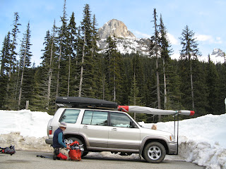
When the sun came up it was shaded by clouds and the wind had picked up so it wasn't as warm as we had hoped it would be. Puffy coats and wind pants kept us warm enough to eat breakfast and we soon were packed up - no dew either night meant the tent was almost dry - except for part of the floor that was sitting in a puddle resulting from over-energetic lawn sprinklers. After a couple of quick stops for gas and for depositing the funds from the fly-in we headed north and up the Methow valley. As we began to climb beyond Mazama, we encountered more and more snow on the roadside until it was higher than the car. About a mile west of Washington Pass we stopped at the small pullout that had been plowed for the Blue Lake Trailhead. We swapped our flying gear for winter hiking/snowshoeing equipment and climbed the snowbank to ge
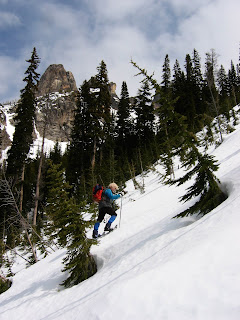
t to the actual trailhead. We had a perfectly good map but the summer trail was totally obscured by the feet of snow so we followed some old ski tracks in the general direction of where we thought (and the GPS showed) the lake should be. The first half mile or so was heavily forested but not too steep, then we hit a wide avalanche chute. Trees were bent over and covered and there was a lot of wreckage strewn around. We stayed near the edge and started climbing pretty steeply up, then it got even steeper. Clearly the summer trail (2.2 mi) took a much less direct route than our 0.75 mile beeline (gaining 1200 ft). The new, smaller snowshoes allowed us to traverse the slope when it wasn't too steep or too firm. After crossing a stand of trees we climbed another avalanche chute, this time using the snowshoe crampons to "frontpoint" straight up. One more tree-covered ridge stood between us and the lake, so we climbed that as well to where we could look down at the snow and ice-covered, narrow tarn at about 6200 ft. I didn't mention that the views had been getting progressively better and better. We could look back behind us to the north to the mountains across the North Cascades Highway, and to the east we could see towering over us Liberty Bell and the Early Winters Spires. We picked a suitably scenic spot for lunch and rested for a while before tackling the descent. Neither of us were sure how to proceed - snowshoe down?, slide on the snowshoes? Take off the 'shoes and glissade? or "heel down". We tried all four and the best method for the day's conditions was to just walk straight down plunging the heel in on each step. We were able to get almost all the way to the car before starting to sink more than a few inches into the snow. The rest of the drive down the North Cascades Highway was suitably scenic with waterfalls, distant mountains and mountain lakes. We stopped for gas at Costco in Burlington and for some groceries and a sandwich at Safeway and were home around 2030 - a good night for a soak in the hot tub. Tomorrow we've got a lunch date with our tax preparer and her co-conspirator, Bill Beck at Easy Joe's in North Bend (a reincarnation of Robertiellos, then Gaston's).

27 April 2009

Chelan Beach 'N

25-26 April 2009

The fly-in was scheduled a week earlier this year so as to avoid the conflict with the Oceanside Open in Oregon. C.J. and I got over there around noon after setting up camp at Beebe Bridge CG where the rates are half-price ($10) for seniors until the Thursday before Memorial Day (likewise after the Labor Day weekend). After checking in with Lori at Lakeside Park we went up and watched conditions from the Butte for a while. There was a lot of virga in the distance but it was otherwise sunny. I launched from "Lakeside" and sank down along the spine until I crossed to the west and got under a cloud. There was plenty of lift; I noted 800 up on my averager at one point. Working my way to the west, I got within a mile or so of the SR 97A summit before turning back. There was still plenty of room to climb below cloudbase (there were hang gliders well above me), but after almost an hour I was ready to land. C.J. was up there with me and was pulling big ears and bigger ears to get down; I did a few asymmetric spirals and then flew out over the lake at about 3000 ft. It was pretty easy to cross but I didn't waste any time when I finally put a breadcrumb on the far shore, and turned around and pointed my toes. There was still 700 ft of altitude left when I reached Lakeside Park and began to set up for my landing. I managed to finesse the light winds enough to hit the white ring, one away from the bullseye. We went back up again with Kevin White but decided not to fly a second round. [I probably should have flown to have been in contention for second place - Tom had first all wrapped up and Brian Scott was second, and Gene (?), a relatively new pilot, was in third place The party commenced around 1800 with lots of pizza and iced beer. However, it was pretty chilly by the time the sun went down and most folks headed indoors. In our case we went back to the campground and had an unusually long sleep.

Down in the Columbia River gorge the sun doesn't hit our side of the river until 0800 or so during this time of the year so we didn't start cooking breakfast until a bit later when it had warmed up some. But by 0915 we were heading back to Lakeside for another flying day. It was warmer and the sky looked to have fewer dark clouds. People were still launching from Lakeside when we got on top, but shortly afterward the cycles began on "Ants". After seeing one yellow PG getting high near where she had gotten up yesterday, C.J. launched from Ants and quickly whipped around the south side of the Butte, through the saddle and almost down to Lone Pine LZ before hooking a good one. She got to do the tour to the west almost to SR 97A and also across the lake before landing. I launched off "Between the Rocks" and worked ratty lift near "Green Monster" with Tom Johns and then tried crossing the saddle. I did manage to climb above the next knob to the west but then ran out of lift and ended up sidehill landing just south of the saddle. After a hurried pack-up, I started to walk up to launch to get the Trooper and got halfway there before Tom and Lori picked me up. After recovering my gear (left at the saddle) C.J met me on top for lunch. We had been seriously considering flying again but the wind had come around to "Monster" and launches were not looking smooth so we went back down to hang out at the park. Later we went back to camp and cooked supper and walked around the campground. C.J.'s sharp eyes spotted a wing in the air on the west side and we decided to go back up to town anyway to check things out. No one seemed to be around at the park so we drove up to launch. Ryan and Amin from Canada were kiting - they said we had "just missed it" but I got my wing out anyway and had an extended flydown to the park. On the way back to camp we stopped for ice cream at the bar/restaurant/ice creamery near Riverside Park across from Campbells - good ice cream, but no samples! It was later than the previous night when we got back to camp and it was warmer so we didn't have to crawl right inside our sleeping bags. Our plan for tomorrow is to drive north and take the recently- plowed North Cascades Highway to make a loop back to North Bend.
(All of C.J.'s photos are from the evening flight, 26 April)

14 April 2009

To Boise and Home


13 April, Monday – Since the dinner at the
Silver Jack Inn was so good, we did breakfast there, too: a fruit smoothie and a “Bum Wrap” consisting of scrambled eggs, bacon, salsa, guacamole and green chiles rolled in a tomato-basil tortilla. Excellent. On the way out of town we stopped at the lower visitors center which really wasn’t open (but the ranger let us in to look at a topo map anyway). Once we got on Route 50/6 we could finally see the top of Wheeler Peak which had been hidden by the slightly lower Jeff Davis. We went up and over a couple of ranges until we reached US 93 which pretty much went straight north along a basin into Idaho. We made a stop for groceries in Ely and C.J. mailed her postcards. Gas was $2.199 which seemed high even for the middle of north central Nevada so we went on with a half-tank. We stopped again for gas ($1.999) and a burger in Wells, NV, where our GPS had told us there was no fast food – obviously, it’s time for an update. Instead of intersecting I-84, we turned west short of Twin Falls and took the US 30 byway past “Thousand Springs” before hitting the freeway again and driving on into Boise. After a quick stop for dinner groceries at Costco (gas is now $1.889, up 18 cents from three weeks ago), we checked in to the motel and had dinner. We met Lisa Tate later for dessert at the Willow Creek Grill on S Vista and she cleared up some topics about recent events.

14 April, Tuesday – We got up early and headed west to be sure to avoid any of the bad weather that was heading in. After a gas stop at Costco near Nampa ($1.829), we drove out of Idaho and up the Blue Mountains where we encountered a snow squall. Fortunately, the snow wasn’t sticking and the rest of the day the weather was okay. We stopped for lunch in Hermiston and for gas again in Union Gap – lousy gas mileage against the strong headwind. Just below Snoqualmie Pass C.J. spotted a bear right by the side of the highway (near MP 47); then we spotted a couple of elk grazing on the side of the road just before North Bend – we got our large mammal sighting quota even on a travel day! We arrived home, where it was obvious that it had snowed recently, around 1600.

12 April 2009

Great Basin National Park


Click on a scrapbook page to enlarge


12 April, Easter Sunday - For some reason I thought it would take five hours or so to get here but leaving at 0915 we were at the Great Basin National Park visitor center around 1215 (PDT). From Bryce we drove through scenic Red Canyon, Panguitch (with its locally-made-brick houses) and over the pass to I-15 and on to Beaver (where almost everything was closed except an expensive gas station). Then we headed west into the Basin and Range geologic province. Several of the basins we crossed had once been part of ancestral Lake Bonneville. Crossing into Nevada we had to finally put away our Roadside Geology of Utah, and turn our clocks back to PDT. At the GBNP visitor center we picked up a map and brochure, talked to the rangers about hikes and declined a tour of Lehman Cave because the weather was too good to spend underground. We decided to try hiking up the Lehman Creek trail which climbs from 7500 ft at the upper Lehman campground (open but with quite a few snow drifts) to 9600 ft at Wheeler Peak CG. The trail started off fairly dry but by the Osceola Ditch landmark at 0.6 mi, there were stretches of snow and by 1.5 mi or so (2 hours) it was all snow and we diverted to the south-facing valley slope where we got a great view of the Spring Valley basin to the east and Wheeler P:eak to the southwest. Coming down was much faster and we were back at the car in a little over an hour. Thank goodness our flying/hiking boots are waterproof; our feet never got wet and cold even in the sometimes sloppy snow. The visitor center was closed before we got back to it so we couldn't check on a map where we had gotten to; maybe tomorrow at the other center in Baker. But we did drive up to try to find the Pole Canyon trailhead and saw some pictographs, and a "wild cave" which could be explored with a permit. We are staying nearby in a four-room motel/restaurant run by one guy who seems to do everything. We had a good meal of Greek salad w/chicken, and several slices of pizza along with a local microbrew, Angel Creek Amber by Ruby (?), and an amaretto brownie with ice cream. We deserved it! Maybe we'll even have breakfast there instead of instant oatmeal again.

11 April 2009

Bryce Canyon and Kodachrome State Park


Click on the scrapbook page to enlarge


11 April, Saturday - We woke up to a couple of inches of snow and realized we had lucked into a chance to see the Bryce colors against a white background. After picking up some not-too-fresh pastries from the bakery next
door, we signed up for another night here, had breakfast and headed for the park entrance. Let's hear it for my "golden geezer pass" (!) otherwise it would cost $25 to get through the gate. We stopped first at Bryce Point, then drove to the far south end of the scenic drive, Rainbow Point. C.J. was shooting pictures right and left, and exulting in the joys of digital cameras. On the way out we stopped at the visitor center and checked with the ranger about roads in GSENM and he thought they would be fine because there was only a little moisture. C.J. found the jigsaw puzzle she wanted so we got that and a calendar that was reduced 80%. Then we headed down to Cannonville, the nearest GSENM visitor center, filling up the gas tank on the way at Tropic. The visitor center was nicely done but the ranger (?) on duty said the roads were too muddy for regular cars, probably. So we went to Kodachrome Basin State Park instead of trying the Hole-in-the-Rock road to Devil's Garden and other hikable places. We'll have to come back to try those places and the Cottonwood Road along the Cockscomb. But Kodachrome was a good choice for the day with a paved road and only five miles from Cannonville. We paid our $6 day use fee and drove the few roads before choosing one of the suggested day hikes - Panorama Trail. We packed up our day packs with rain gear and lunch and headed off into the maze of red rock spires and canyons around 1400. We took short detours to see "petrified lightning", "old Indian cave" (good lunch spot), "the hat shop" (columns with cap rocks), and "secret passage" where we got to walk on some slickrock rather the usual sand. About halfway through the 4-mile loop, we decided to take the Big Bear Geyser Loop for an additional two miles (and that was after we missed a turn and wandered up and onto a somewhat shaky ledge way off the route). We saw the "geysers", actually petrified-sand geysers with no hot water involved anymore, and went way up a slot canyon. Shortly after we got out of the canyon the weather finally turned bad on us and it started to rain. Fortunately it didn't last long and hardly got our rain parkas wet. We were glad to reach the Panorama Trail again and be making progress toward the car, which we reached around 1730. Just as we were pulling out of Kodachrome, it started to rain hard - phew! just made it. It was just a shower, again, but back up on the Paunsaugant Plateau near the entrance to Bryce we ran into a real snowstorm. But by the time we picked up some Subway sandwiches for dinner and got back to the motel, it had stopped. Great day! Glad we stayed here for the extra night.

10 April 2009

Capitol Reef and GSENM

Click on the scrapbook page to enlarge


10 April, Friday - We were surprised yesterday that the campground filled up, but it's almost Easter weekend, so I guess it's still spring break time. Today we got up pretty early in the cold (low 40's?) even before the sun reached the campground, packed-up almost everything but the tent, and went over to the visitors center. The
same couple who did last night's presentation were on duty and suggested we visit the pioneer schoolhouse, petroglyphs, hike to Hickman's (Natural) Bridge,
(Hickman's Bridge, Capitol Reef NP, left)
and then drive the scenic tour down the center of the waterpocket fold and hike Capitol Gorge, a narrow, tall, canyon, to the pioneer registry (names chiseled on the rocks dating back to 1887) and the (waterpocket) tanks. We did all that in unexpected sunshine since the forecast is for snow or rain this evening. If the forecast hadn't been so grim for camping we probably would have stayed another day.

As it was, we packed the tent and left Capitol Reef sometime after 1300. We stopped for brochures in Torrey, then
drove SR 12, a scenic byway, over Boulder Mtn (9600 msl) with views to the east of Capitol Reef and, nearby, of aspens in snow. At some point between Boulder and Escalante we decided that we needed to find a motel for the night because the precip. prob. had increased to 100%. C.J. found us a deal at Fosters motel/steakhouse/store/bakery, which is being renovated, right outside the entrance to Bryce Canyon NP. After driving through
Escalante,which looks like a major outfitting area for the Grand Staircase-Escalante National Monument, we stopped at the GSENM multi-agency visitors center in Cannonville.
(C.J. in Capitol Gorge, Capitol Reef NP, left)
Scenery along Route 12 had been great but we hadn't been off the highway at all. One ranger suggested a late afternoon hike but we were pretty much hiked out for the day so we drove on to our motel. The room turned out to be fine but we have to step over tools and such in the lobby to get to the newly pine-paneled room. Later we went to the Bryce Pines Restaurant for huge burgers for dinner and a slice of one of their "famous" pies for dessert. (Coulda passed on the pie.) The sky definitely looks threatening and snow is forecast for tomorrow up here at 7500 ft. We'll decide if we'll stay or go in the morning. Bryce is supposed to be really scenic in the snow...

09 April 2009

Valley of the Gods to Capitol Reef

Click on scrapbook page to enlarge


9 April, Thursday - Just outside of Mexican Hat we stopped to photograph Mexican Hat, the formation, not the town. A little ways farther and we turned towards Bluff and then north onto a gravel road signed "Valley of the
Gods". It was a 17-mile route through a smaller-scale Monument Valley. Great, closeup views of red rock towers, fins, spires and Buttes! Back on the main highway (SR 261) we drove right at a red rock wall not knowing if we would go around it or through it. It turned out that the Moki Dugway went right up the face of it in a series of switchbacks, some of which were unpaved. [Apparently the MD was constructed to bring loads of uranium ore to the mill at Mexican Hat, where the tailings are now covered by a limestone cap which looks from a distance like a gray lake.] That put us up on Cedar Mesa where we stopped at a ranger station and noted all the hiking opportunities in the area. The mesa is also home to Natural Bridges National Monument. We picked up some information at the visitors center then drove part of the loop until we reached the overlook and trailhead for Kachina Natural Bridge. We hiked down the 1.2 miles and 600 vertical feet to the bottom of the canyon and got some photos of the bridge and the nearby petroglyphs and ruins - different here from those in Bandelier - more like pithouses than pueblos, more Fremont culture than Ancient Pueblo/Anasazi. It was sunny and warm so we had a picnic at the Bears Ears overlook before heading off Cedar Mesa down White Canyon, past Hite to an overlook near Lake Powell. We filled our gas tank at Hanksville not wanting to be low in country where the gas stations seemed few and far between. Then we drove up the Fremont River canyon all the way to Capitol Reef National Park. Since it was warm enough and not too windy we set up our tent in the NP campground and cooked supper. At 1900 there was a good natural history Q&A at the amphitheater where we got a couple of our questions answered.


08 April 2009

Canyon de Chelly and Monument Valley


Click scrapbook page to enlarge


8 April, Wednesday – Here we are in Mexican Hat, UT just north of Monument Valley, much farther along than I thought we would be today. We got out of Albuquerque reasonably early and pushed right along so our first stop was at a really good visitors center at the Grants exit from I-40. After that we continued along I-40 to Gallup and headed north to Window Rock and Ganado where we stopped at the old Hubbel Trading Post which is now a National Historic Site (but still sells cheap souvenirs and expensive Navajo rugs, etc.) By this time the forecast wind was strong enough to keep us from eating lunch outside so we ate on the road. The wind kept increasing and soon we were driving in a sand and dust storm.(photo above left) In Chinle we turned east to Canyon de Chelly Nat Mon, stopped in the visitors center briefly, then drove the south rim road and stopped at all the turnouts.(photo left) The views were good but not as spectacular as they would have been without the dust in the air. Temps were up in the low 60’s but the wind kept the comfort level pretty low. We had sort of planned to camp at Canyon de Chelly but the wind and blowing sand was too much, so we headed on northwest toward Kayenta and Monument Valley. We were really glad to climb out of or beyond the sandstorm and in to blue sky again before reaching Kayenta. The buttes were spectacular in the late afternoon light and we debated what we should do – try to stay at an expensive Kayenta hotel, camp at Navajo Nat. Mon (1300 ft above Kayenta and still somewhat snowy), or move on north to wherever. We tried the first option and found out that all the hotels were full (Huh? In April?). Camping seemed possible but the wind was the dealbreaker so I called the one-star motel in Mex. Hat and got a room. After picking up some dinner we started north through Monument Valley and had great evening light and clear skies for C.J.’s photography.(photo left taken earlier) Descending 1800 ft from Monument Valley, we found the San Juan Inn (photo right)overlooking the river of the same name and finished up our shrimp appetizer from last night. The Mexican hat of the town name is a flat-topped balanced rock on the ridge above. We’re glad to be here during this season, even if all the rustic kiosks along the road aren’t staffed with Navajo vendors, because our host says it is typically 110 degrees in the summer. Cool but comfortable now, and the wind has pretty much stopped.

07 April 2009

Los Alamos and Bandelier National Monument


7 April, Tuesday - By 0845 we were packed up and out of Red River on our way through Taos again. The road descended for a while and paralleled the Rio Grande in a canyon. Then past Espanola we began climbing to the mesa-top location of Los Alamos. We spent a couple of hours in the Bradbury Museum watching both movies and looking at the displays of history and current explorations. We left without having exhausted the museum's possibilities.


From there it was only a short drive to Bandelier where we descended the CCC road to the valley bottom. The visitor center provided us with a guide brochure and we set out on the 1.2 mile main loop to see the Ancient Pueblo People (formerly known as Anasazi) ruins (AD 1200-1400). There were longhouses, cliffhouses, kivas and caves (cavates - "cave eights") as well as petro- and picto-graphs. It was short-sleeve weather in the sheltered valley and later we saw the temp climb into the 70's near Albuquerque. We took the Jemez Mountain Byway around and through the Valle Caldera and past some really red rock cliffs. Around 1800 we checked into the La Quinta Northwest in Albuquerque, cleaned up a bit and then met Steve Hill for barbecue at the County Line near the Sandia tramway base. Great meal and great to catch up with Steve!

Wild Rivers and Great Sand Dunes


6 April, Monday - The day dawned sunny...and cold. We drove down through Questa then north and west to the BLM's Wild Rivers park. After paying our fee (half of $3, love that "golden geezer" access pass!) we stopped at a couple of pullouts to look into the Rio Grande gorge. Then we parked in the La Junta trailhead and hiked down the trail and stairs, losing 800 ft in the process, to the junction of the Red and Rio Grande. From there we continued north along the River Trail to the Little Arsenic Springs CG (sheltered picnic tables, tent pads and outhouse on a bench above the river) and up the trail to Little Arsenic TH. The walk back to the car along the Redondo (?) Trail was anticlimactic after the scenery in the gorge. But the mountain sheep we surprised just outside the parking lot was anything but boring. Wasting no time (it was already after 1300) we hurried north to Great Sand Dunes National Park.


This time the sky was clear and blue. The dunes stood out sharply against the snowcapped Sangre de Cristo range as we walked out on the dune field and up one of the nearby dunes. The wind was light and the temperature was moderate - no snow and howling winds this time. After taking photos of dune crests, ripple marks and "sand angels", we drove through the juniper-shaded (but still somewhat snowy) campground and on to Alamosa for a Starbucks break - thanks for the card, Irina and Andrei! We took the alternate route back, crossing the Rio Grande way above the gorge and taking a detour to see the stupa at "Lorien" near El Rito. It was nearly 1930 by the time we got back to the condo at Red River but the evening light on the canyon cliffs made it worthwhile.

05 April 2009

Enchanted Circle tour


5 April, Sunday - Instead of a shower and breakfast, I dressed for skiing and went out to brush the 4 inches of snow off the car. I found the visitor center
open but no one on duty so I headed up to Bobcat Pass (9600 ft) to see if it was possible to ski at the Enchanted Forest Cross Country Ski Area. The main road in town was plowed but the plowing stopped at the edge and I followed a few tire tracks to the boundary of the national forest before reaching EF. That put it on private land, and the conditions didn't look that great anyway so I went back to the condo for a great C.J.-prepared breakfast of bacon and pancakes with fresh pear sauce. Later we drove down into Questa, past the big Chevron molybdenum mine, then south to SR 64 which has a well-known bridge spanning the 650 ft deep Rio Grande gorge. After some photos we browsed the vendors' wares and C.J. bought a small SW-style fetish bear pendant. Then we drove into Taos, parked and wandered around the old town for a half hour or so.


From there we headed north and, since the sun was shining, we stopped for a picnic lunch on a south-facing rocky slope. The route was scenic and the weather was sunny with dramatic cumulus in a bright blue sky; we could finally see the summit of Wheeler Peak (over 13,000 ft). We drove into Angel Fire not so much to see the resort but to access the only Bank of America we had seen for days.


Right up the road was the Vietnam Veterans Memorial State Park and we stopped to admire the architecture and striking setting on a hill above the Moreno Valley.


Continuing north we passed Eagles Nest and wound down Cimmaron Canyon past The Palisades. When we reached Philmont Scout Ranch we found that the visitors center was closed on Sundays but I took some pictures of the vaguely-remembered headquarters. There were herds of deer nearby, and as we reached the top of Cimmaron Canyon we saw a trio of wild turkeys - they must be more common now. We climbed over Bobcat Pass (this time on dry roads) and were back at the condo in Red River by 1700.