
North Matthieu Lake near McKenzie Pass
17 Oct – After a not-so-early start, we drove over Snoqualmie Pass, got some gas at Safeway in Cle Elum, then filled up at Costco in Union Gap. We arrived at Eagle Crest Resort about 1700 and checked in to the upper floor of a 3-BR condo way down the end of the Falcon Crest cul-de-sac.

Tam McArthur rim panorama
 18 Oct – After talking with Steve Roti about weather and activity options, we decided to do the hike to Tam McArthur Rim. We left around 1030 and took the kayak with us in case we wanted to paddle in Three Creek Lake 16 mi south of Sisters. We missed the trailhead and drove to the end of the road in an empty FS campground with a few yurts. Backtracking, we found the trail at the other end of the lake (6500 ft) and started steeply up and around the wall above the lake. Less than a mile along we entered the Sisters Wilderness Area and the grade
  eased and we passed out of ponderosa pine into limber pine and later through stands of subalpine (?) or noble fir. Our lunch spot was a promontory on Tam McArthus Rim at about 7700 ft, some 2.5 mi and 1.5 hrs from the car. After lunch we explored along the rim a bit farther until the trail started
  dipping down toward a low point beyond which was a lingering snow bank. We met only a few other hikers on the trail and made good time back to the car. Too tired to consider paddling in the small lake, we headed back to the condo and dinner. Later, we drove to the Eagle Crest Resort lobby and used the wi-fi to pick up email and download other stuff.
 19 Oct, Tue – Steve called to let us know that the weather looked marginally better for flying but we were off to get tires for the Outback at Costco and didn’t have our wings in the car anyway. We thought it over and decided to
  get together for a paddle when Tina got back from a class. After some minor Costco shopping we drove out to the Bend Factory Outlets and I looked for some trail shoes to replace my worn-out pair at Columbia Sportswear. I didn’t find any that fit perfectly, but maybe there will be something at the FM anniversary sale. After getting some cash at BofA, we got gas at Arco (2.819) and had some lunch. We met Tina and Steve at the Powder House parking lot around 1330 and followed them
  up to Sparks Lake, west of Bachelor Butte. We had the lake to ourselves and paddled along the lava shoreline and up several narrow inlets. In one inlet we could hear the water gurgling as it drained down into the passages that connected Sparks with the next lake downstream. This late in the season the water was very low and we scraped the sandy bottom several times and had to paddle without a rudder some of the time. By 1630 we were reloading the kayaks on the cars ready to head back to town. C.J. and I stopped to pick up some avocados, tomatoes and apricot ale for dinner with the Rotis. Steve also invited Steve and Nona so we had a good crowd for another Tina-prepared feast. We got back to the condo by 2145.
 21 Oct, Wed – Another beautiful day with crisp temperatures and bright blue sky. We decided to do another hike and headed for McKenzie Pass and the Matthieu Lakes Trailhead (arrived 1130). There was only one other couple gearing up to do the same hike and we checked with them on the correct trail since we did not have a map. A short segment of trail led to the Pacific Crest National Scenic Trail and we followed that about 2.5 miles through forest and across
  some openings on a ridge to South Matthieu Lake. We had lunch on the far side of the little lake then started down the trail past North Matthieu Lake to make a loop. It was only another 2.5 miles along the moderately-sloped trail to the parking lot. Since it was still early, we drove the short distance to McKenzie Pass and found the Dee Wright Observatory, built by the CCC of lava chunks from the lava field it sits above. Some of the windows were arranged to frame the surrounding mountain peaks so we were able to identify some that we weren’t sure of. From there we
  backtracked down the scenic, old (narrow, no shoulders) highway and stopped in Sisters to look around a bit and buy a postcard. The last item on our agenda for the day was to pick up some groceries, a watch for C.J. and a pair of trail shoes for me, all reduced in price for the Fred Meyer 88th anniversary sale. After a yummy dinner of zucchini soup we went over to the hotel lobby to download email and do other online chores.
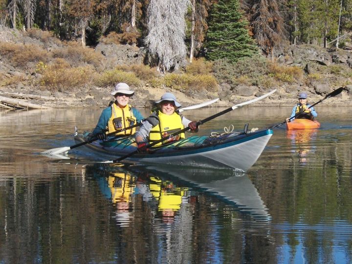
 22 Oct, Thu – We met Tina at her house and fastened her light, twelve-ft Current Designs kayak against ours so we could all ride in one vehicle. We drove about 35 miles along the Cascade Lakes highway to Hosmer Lake boat ramp. There were only two other vehicles in the parking lot and we only encountered two other boaters or fishermen during our paddle. We paddled along the perimeter of the open water and through relatively narrow channels between reed beds. Near the northern
  end of the lake we followed Quinn Creek up to a good pull-out spot just below a low waterfall where we had lunch. The water was a little low in the creek but that was the only place we had to pull up the rudder. It was still pretty early when we returned to the boat ramp so on the way home we stopped at Elk Lake Lodge thinking to get a drink or some ice cream but it was closed (in between seasons, I guess, because it is open in the winter for snowmobilers and skiers). C.J. and Tina decided to sit on the patio in the sun and look at C.J.’s
  Nepal scrapbook. Back at Tina’s, we had a snack and then took a quick shower before following Steve to McMenamin’s Old St Francis School for the USHPA “icebreaker” at 1800. After schmoozing for an hour-and-a-half, we headed back to the condo for dinner and to meet Bob H who arrived around 2100.
23 Oct, Fri – We spent the day at the USHPA board meeting at the Phoenix Hotel in downtown Bend. First we studied all the nominations for awards and made some notes. Then we took a break and went to “lunch” with Mark Forbes at Goody’s, a candy shop/soda fountain on Wall Street – a sundae for lunch! We got back for our Awards Committee meeting a little late but managed to get all the awards sorted out by about 1500. The only two that really needed any discussion (because there were more than one candidate) were the Paragliding Instructor Of The Year (Benoit Bruneau, Kevin McGinley) and Promotional Video (“Zippy”, “Torrey Pines” by the La Jolla Historical Soc.). The rest of the afternoon we talked to other directors and staff and C.J. typed up the minutes of the meeting. On the way home we stopped at Fred Meyer for some groceries and a new clock for C.J.’s night stand. We also filled up our gas tank there at the unbeatable price of $2.829, and that should get us back to Yakima.
24 Oct, Sat – Again we spent the day at the Phoenix. This time for the General Session – lasted to almost 1800. There were a couple of breaks and, since the weather was better than forecasted, we walked down to Drake Park for a picnic lunch in the sun amid the falling leaves. The Board chose Kitty Hawk, NC, as the site for next fall’s BOD meeting. We were already considering going “Back East” for the fall colors and now may consider attending the BOD meeting as well. It coincides with the 100th anniversary of the first flight. New officers were elected and Bill Bolosky is back in as an Exec Comm member and secretary, Mark Forbes remains treasurer, and the new president (We’re guessing that past-pres Lisa resigned so she could apply for the Exec Dir position.) is Rich Hass, another Region One pilot. Later, Belinda and Davis met us at Eagle Crest for dinner and we had a good visit.
25 Oct, Sun – It was pouring rain and very windy as we ate breakfast but stopped when it was time to load the car. Since there were some patches of blue sky, we took the scenic route (well, new route anyway) to Prineville then up SR 26 through the National Grasslands to Madras. We ran into some downpours and strong winds along the way, enough to push the bow of the kayak out of alignment with the car. Maybe I need to put the front cradles closer together. We also had some wonderful sunbreaks and fall color so it wasn’t a bad trip at all. We got home around 1630, early enough to pick up some books at the library that had been on hold since last Sunday.


