Or, Traveling the Alaska Highway 2009
(click on a photo for a full-screen view; click on your browser's back button to return to blog)) A return to Alaska has been on our list since our last trip via cruise ship and rental car a dozen years ago
.
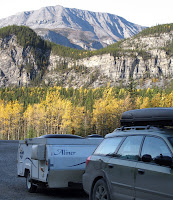
Finding a used Aliner Sport
trailer at an affordable price made this late season trip possible. We drove north via the Cassiar and Klondike Hwys, and returned via the Parks, Glenn and Alaska Highways. No bugs, no crowds and mostly wonderful fall weather!
9/13/09, Sun – We were still working on packing and preparing/preserving food from the garden for an early start, but we did get off shortly after 1100.
We stopped in
Burlington for some cheese at FM and gas at Costco.
That morning I had taken a look at the tires on the trailer and was concerned about the cracks in the one on the driver’s side.
At Costco I asked the tire guys to check and they were not overly concerned about imminent failure but I decided to replace the worst tire with the spare while parked in the shade on the far side of the parking lot.
After getting gas, I went back over to the tire service area and asked them to increase the tire pressure to 36 psi (up from the 22 psi we had traveled from Indy with – should have checked that!). Costco did not have any ST tires available and both Les Schwab and Discount Tires were closed on Sunday.
We crossed the Canadian border at Sumas (no problem) and drove up through Hope and the scenic Fraser River Canyon. We spotted one paraglider in the air at Bridal Falls but the LZ was crowded with Search and Rescue vehicles. We camped at Skihist Provincial Park, near Lytton, a really nice, pine-shaded, hillside campground far enough away from the train tracks that we could barely hear the whistling and screeching.
It was warm (Spences Bridge nearby is known as the Hotspot of B.C.) so we prepared dinner outside

on the picnic table and needed only a light cover for sleeping. After dinner we took a walk in the dusk
down to the highway and across to
the picnic area which had a view of the Thompson River Canyon. (photo, left, Kid Kodiak wanted blueberry syrup on his pancakes)
9/14/09, Mon – It was a pleasant morning so we cooked some pancakes outside and still got a reasonably early start. Not far up the road, just beyond Spences Bridge, there was a “sheep jam” with a dozen or more bighorn sheep grazing right along the edge of the road.

We also stopped at a fruit stand along the river to pick up some apples (Spartans and McIntosh) and some peaches. At Ashcroft we slowed down to see if we could remember where we had flown our hang glider way back when (nah) and then stopped in Cache Creek to get gas(108.9 CDN). Shortly before 70 Mile House we followed the recommendation of The Milepost and took a loop road that brought us to (Painted) Chasm Prov. Park. It was an erosional feature caused by an ice age waterfall which had gouged out a canyon in flat-lying, colorful layers of lava. Our next stop was at Begbie Lookout just before Williams Lake where we hiked a short trail to the summit for a view out over the southern Cariboo (photo, left, below).

Back on the road we drove on to Quesnel (kwe NELL) where we stopped at Walmart to have someone look at the tires again. The tire guy wasn’t too worried about the age checking but sent us to Tireland where another guy said they were fine and that there would not be a problem finding replacements along the way (Try Kal Tires or Fountain). By then it was getting kind of late but we headed for Prince George and followed the GPS directions to the CAA office to get a 2009 NW Canada Camping Guide. We gassed up across the street at Canada’s Real Superstore (sic) and headed on to find a place to camp. Walmart was out due to construction, there were specific injunctions against camping at the rest area, so we pulled into the first decent RV park (Dave’s in Vanderhoof) and got the cheapest, no hookup, back-in site. But it came with free showers and a nice big room with tables and electricity where I am catching up on this blog. Tomorrow we’ll continue NW up the Yellowhead Highway to the Cassiar Highway which goes more northerly.
9/15 – Late start at 0921, in fog (Wait till later in the trip if you think that was a late start). We spotted a coyote as it was about to cross the Yellowhead Hwy and found that Beaumont PP was closed just as Dave said it would be – days ahead of the published closing date. We stopped at a rest area that had a cairn with a stone from Castle Tintagel, reputed birthplace of King Arthur. Six Mile Summit north of Burns Lake had some bright yellow aspen. Passing through Houston we saw the “World’s Largest Flyfishing Pole”. We stopped in Smithers for the Tourist Info Ctr, walked to the BC liquor store for a six-pack of Growers hard apple cider, and continued up Main Street to the statue of an alpenhorn player. I bought a package of wire splices to reattach a broken brake wire when I can work on it in the dry. It started to sprinkle as we left so we could barely see Hudson Bay Mtn. At Moricetown Canyon and Falls we detoured off the hwy to see a native fishing site – there were First Nation people there but no one was netting. (photos, left, below)


We also drove into Hazelton and walked along the river in a drizzle looking at some of the historic buildings. Back on the Yellowhead we got gas at New Hazelton and continued on the 43 km to Kitanga and the turnoff for the Cassiar Highway. There was a detour through the village of Kitwanga with old totem poles and bell tower. We saw our first bear, a young black bear , on the side of the road maybe 20 mi up the Cassiar. There were also several eagles in the trees. We got to Meziadin (mez ee AD in) PP after 1800 and chose a campsite right on the beautiful, still lake.

(I received some advice about backing the trailer into the site from an experienced trucker and did better afterward.) Rain finally forced us inside after C.J. had just finished cooking at the picnic table. We went to bed early as the rain continued.
9/16/2009, Wed – We left the trailer in the Meziadin CG and drove to Stewart, BC and Hyder,  AK in cloudy/foggy weather. There still were good views of waterfalls and the Bear Glacier along the road. There was a no-stop border-crossing into the US after passing through Stewart (TI was closed). We visited the Fish Creek Wildlife Viewing area run by the USFS - our Golden Age passes saved us the $5 fee to enter the boardwalk and observation area. We could see the spawning salmon in the shallow, clear stream but there were no bears to be seen. The 30-mile Salmon Glacier self-guiding tour took us up to a summit where the huge glacier was intermittently visible in low clouds. Continuing on we had better views and farther on good views of
  another large glacier. We turned around when we ran out of road (except for the mining access tracks). Back at Hyder we bought some expensive Orowheat bread and then drove to Stewart for some likewise expensive gas (118.9/l). The boardwalk out over the estuary amused us for a while until it started raining, then we drove back to the Fish Creek bear observation area and stayed until 1800 but without any luck. Back at camp by 1900, we cooked and ate outside in the mostly cloudy and cooler weather.
9/17/2009, Thu – We didn’t leave Meziadin PP until 0915 because I wanted to try to get the trailer brakes working (better? At all?) by repairing a broken wire near the driver’s side hub. I think I was successful but the brakes are not grabbing any better even on the highest setting. As we drove north the scenery got better and better and the aspens became more golden. We stopped ar ound noon for a 1 km hike to Natadesleen Lake in cold, windy conditions. (photo, left, C.J getting a photo of bearberries) I didn’t think to bring the bear spray so we w
 ere reduced to making noise as we walked along. Since I had put only 8 gal of gas in at Stewart we knew we had to get gas, preferably before Dease Lake. But the station at Iskut was closed so I drove conservatively to Dease where gas was 120.9/l – but fresh pumpernickel bread was only $2.99 (compare to $5.99 for Orowheat in Hyder). It wouldn’t have been the Cassiar Hwy without some gravel breaks and we encountered a strech of smooth gravel just before crossing the Stikine River. We made two photo stops for our bears –
  Northern Bears Gift Shop in Dease Lk and at the Rabid Grizzly Rest Area. But we saw no real bears, moose or other large mammals. We arrived at Boya Lake PP around 1700 and found another beautiful lake and a lakeside campsite among the golden aspen and spirelike spruce. After setting up camp (piece of cake with a pull-thru site) we took the 4 km nature trail along the
  shore (wet) and up an esker and down to where a beaver had partially dammed a tributary to the Dease River. Too bad someone had removed the interpretive signs. The stars were great at night with the North Star much higher than near Seattle (We were at something over 56 deg N latitude). In the early morning we waited out a shower so got up a bit later (0730) than usual. It didn’t get as cold as we expected due to the cloud cover later in the night.
9/18/2009, Wed – We left Boya Lake PP at 1000 after Welsh griddlecakes, and a hair wash for me. Just a few miles beyond the Yukon border, at the intersection with the Alaska Hwy we turned east instead of west and drove ten miles or so to Watson Lake.  The “sign forest” was even huger than I had imagined, and we picked up useful Yukon Territory info and coupons from the visitor welcome center. We watched a DVD on the building of the ALCAN (although that term was never used) and then bought some high priced gas ( 118.9 CDN, a bit less than the 120.9 CDN at Dease Lake) and headed W (only to have the GPS tell us to follow an unpaved loop back to the Alaskan Hwy). We stopped again for gas in Teslin at a trading post where the gas was surprisingly cheaper (108.9 less 4-cent coupon) than in the larger town of Watson Lake. Whitehorse was what we aimed at but we were thinking about stopping just short of the city in a Yukon gov’t campground. We even stopped and checked it out – nice place but nothing to compare with Boya or Meziadin. Besides, just beyond Whitehorse was another Yukon gov’t camp right on the shore of Lake Leberge (photo, left, below).
 We couldn’t resist the chance to camp on the “marge of Lake Lebarge”* so we pushed through Whitehorse with a stop for gas (great price – 100.9 CDN) and rotisserie chicken (not great price – 7.98 CDN) at Canada’s Superstore. Leberge was another wonderfully scenic campground and we chose a site that overlooked the lake after walking the CG loop to see if it would be too hard to turn around as the sign suggested. It was pretty chilly but dinner was fairly simple and firewood was free so we had dinner around the fire as it got dark. As we started to get ready for bed we found out that the battery was too low to power the furnace for more than a few minutes. This was despite having traveled many miles with the car alternator sending power to the trailer – apparently the refrigerator was sucking up all the juice. We piled on the fleece sleeping bag, down comforter, and the quilt and slept comfortably. In the morning I hooked up to the car and idled it while we ran the furnace long enough to warm up.
*(The Cremation of Sam McGee by Robert Service)
9/19/2009, Sat – The problem with Yukon gov’t campgrounds is that the water pump has a sign on it saying that you have to boil the water for 10 min. We checked another camp along the way and it was the same. Fortunately we had 8-10 gallons in the trailer tank plus whatever we have in the eight-liter collapsible water container, so there never was a time we felt concerned about having enough w ater. As we traveled farther north, the bright yellow fall color of the aspens began to dim, and we also got some rain. We stopped to walk a 200 m interpretive trail for the Fox Lake Burn just to stretch our legs. We got gas in Carmacks (108.9 and a 4 cents off coupon) but the TI was not open after we finally found it. The overlook at Five Finger Rapids (photo, left) was good enough for us; we skipped the excursion which began with 219 steps down to the trail. We also made quick stops for a leg stretch at Pelly’s Crossing and Stewarts Crossing, and to read the info panel on the Tintina Trench. It was grey and gloomy when we reached Dawson City with its unpaved streets, old buildings, and most businesses (including the RV Park) closed for the season. We did get to visit the Welcome Center and ask about
 camping, the Top of the World Highway, the free ferry across the Yukon River, and the U.S. border (all were open). Before heading back out of town to the one open RV park, we stopped to get gas…and pulled right out again when the price (284.9) was at least double what we had been paying. Fortunately we found another gas station near the Bonanza RV park where gas was “only” $128.9/l. Bonanza was the gravel parking lot type of RV Park but we were able to plug in and charge the battery, run the heater and use the warm bathrooms and hot showers (3 min/$). After dinner we took the advice of locals and went to the casino for Diamond Tooth Gertie’s dancehall show (no admission but the two drinks were about $14, same as admission would have been). It was fun to go out for a show, and it was the last performance for the year.
9/20/2009, Sun – We didn’t get up until 0830 because it was dark and gloomy (We were, after all, close to 64 deg north latitude!) especially after rain overnight. After breakfast (real oatmeal, for a change) we fired up our computers to pick up email now that we had the appropriate password. Unfortunately neither of us could send email via our usual program.  There was hardly any wait for the free Yukon River ferry (photo, left) which looks something like a barge and has no ferry slip – it just noses into the riverbank and drops the ramp. By 1030 we were grinding our way up the steep climb to the Top of the World Highway, mostly gravel, mud and wet. The car and trailer were soon plastered with a coating of brown. A lot of the time we were in cloud or fog with occasional breaks (but we couldn’t wait for good weather because the border would be closing the next day). By noon there were more breaks and we stopped
 just short of the border at the highest point on the highway for a walk to a cairn on a nearby hill. The border crossing was just a formality but the young border guard was from Sussex, NJ, not far from where C.J. was born and raised. The road was even worse in AK – there weren’t even any asphalt breaks - and it was pretty slow going, but it was mostly downhill. We stopped at a BLM campground (Walker Fork) which had good sites, mostly pull-thrus, but probably no water (the pump handle was missing).
  C.J. noticed that we had lost a bumper cap and our drain hoses were escaping. We duct-taped everything in place and headed back up the road a mile or so to see if we could find the cap. After no success in two miles I turned around and headed south again. Thinking I had maybe spotted the cap I stopped and backed up – bad idea with the trailer. With just a moment’s loss of concentration I jackknifed the trailer and put a big dent in the side of the car above the wheel well. Fortunately no one was hurt and both the car and trailer were drivable (and continued to be drivable for the rest of the trip). We were both shaken and bummed but continued on to Chicken
 (The story is that the townfolk wanted to call it Ptarmigan but could not agree on the spelling so they settled on Chicken, which is what locals call the ptarmigan anyway.) The big gift shop-convenience store-RV park-gas station was already closed for the season but we stopped to walk around the big gold dredge and drive through the rest of the town. By 1700 we were ready to call it a day and C.J. convinced me to try “informal camping” (legal now that we were in AK) at the Mt. Fairplay rest area. Before setting up we walked a ways down a herd path which was all spongy mosses. We returned to the car for waterproof boots and blueberry picking implements and picked enough late-season blueberry/huckleberries for pancakes in the morning.
9/21/2009, Mon – Yes, the pancakes were good even if the berries were a bit overripe. Still, by 0900 we were on our way down the Taylor Hwy to Tetlin Jct and the Alaska Hwy. We got gas in  Tok (sounds like "clock") for $3.58/gal, cheap after Dawson (and all of Canada, for that matter). The road now was quite different being wide, relatively level and straight. Since we were considerably lower in elevation (and latitude) we had fall color again. There were even some paper birch and larch in the northern boreal forest up here. We stopped at a visitor center in Delta Jct, even though it was closed for the season, for photos of the “end of the
Alaska Hwy” sign, giant Alaska mosquitos and the bears in a high cache. The snowy Alaska Range was visible to the south, the part with McKinley/Denali to the SW, and we crossed several obviously glacial
rivers including the  Tanana (TAN ah nah).
.
 After lunch we stopped at The Knotty Shop, a gift shop noted for the figures crafted out of gnarled logs and burls (and for the buy-one-get-one-free ice cream deal). We got into Fairbanks about 1430 and eventually found the TI with a small but well-done exhibit of Alaskan life. As expected, most tourist attractions and campgrounds were closed. We could drive back to North Pole or camp at Walmart. (Guess which one we chose) Same for Denali NP – only one CG open and the shuttle bus had stopped running on the 17th…and there was snow there. Next up was a car wash to peel off the pounds of mud on the car and trailer. Then we headed for Walmart for an oil change (which took a lot longer than expected) and some grocery shopping at Fred Meyer. I got a new air filter at Schucks and tried to get a new tow bar to replaced our now twisted one but U-Haul was closed for the night. So we got gas at Safeway ($328.9/gal) and settled into an RV slot at Walmart for the night. It looked like we would be the only ones “camping” there but later more RVs and trailers and vans pulled in. Back in Walmart in the evening (for the rest room) there were almost more people in Army unifo
 rms than civilians. Fort Wainwright is nearby and there is a Stryker brigade there. (photo left - the Lend Lease Airlift Memorial, Fairbanks) Dinner was great as usual – C.J. has continued to produce great meals without buying anything special.
9/22/2009, Tues – From Camp Walmart we went to the U-Haul store to get a replacement for our twisted hitch bar and fill the 5 gal. propane tank (it took about 2 gallons so we would have had plenty left for the rest of the trip…probably). The weather was pretty gloomy so we decided to do something indoors in Fairbanks.  The Museum of the North is on the campus of AUF – Alaska University Fairbanks – and has both anthropological-natural-historical displays and the Rose Berry Art Gallery. We spent the maximum time we had paid for parking – four hours – seeing as much of the museum’s displays as possible.
  Around 1415, pretty much museum-ed out, we headed south for Denali in low clouds and fog and an occasional spit of rain-snow mix. By the time we reached Denali it had been snowing steadily for a while and there were a few inches on the ground (but not on the road). We drove in to the “visitor center campus” and talked to the rangers, saw the movie “Heartbeat of Denali”, and toured the excellent visitor center displays. An hour later we were the last tourists out of the VC for the year – it was closing down. Riley Creek Campground had one loop open – the Bear Loop – and there was no fee. There was no water either, but the outhouse at least was unlocked. We set up the Aliner right across from the rest rooms and I hooked up the generator for the first time to insure that we would have heat for the evening and morning. I think I ran the generator two hours or so in the evening and two hours in the morning connected directly to the AC power cord. It seemed to work because the furnace got a workout in the subfreezing temperatures. After setting up and taking a couple of short walks around the campground C.J. noticed that the sky was clearing and it was no longer snowing. She convinced me that we should go out the Park Road as far as possible because the weather might be as bad as it was forecast to be tomorrow.

Even though the sun was going down we drove out almost to the Savage River Bridge at the 15-mile mark. On the way we saw some moose not too far from the road. Then we saw a couple of cars stopped and we pulled into the turnout with them. There were two cows, a young moose, and then a bull appeared and caused a

minor scramble of the tourists. C.J. captured several good shots of the moose from non-telephoto close.
The sunset was spectacular too with all the snow contrasting with the color. Back at Riley Creek we had chowder for supper and then dug out an extra fleece blanket to add to the one we already had AND the down comforter AND the quilt. The temperature was definitely below freezing and it was snowing lightly as we went to bed. As it turned out, we were warm enough all night with the bed covering we had and without running the furnace during the night as at least one of our (very few) campground RV neighbors did all night. There was also a young couple with a tent and a inflatable mattress in the campground. They were gone by morning; I hope they didn’t shiver all night.
9/23/2009, Wed – Morning dawned bright and almost clear, totally unexpected. (photo, left, our campsite at Riley Cr CG) We got started  around 1000, left the trailer set up and went to the Murie Science and Learning Center which is the winter stand-in for the Visitor Center.
The ranger told us that the Park Road was open to private vehicles all the way to Teklanika, 30 miles

in from the highway. We had been thinking about a hike but decided to go to the end of the road first and maybe walk along the river out there. The farther out we went, the deeper the snow and the better the views – Mt. McKinley/Denali (photos, left, below)
 was visible for much of the drive (as soon as we figured out which distant peak was the one) and the air was crystal clear with a bright blue sky (and the temperature on the car thermometer showed a low of 16 deg F at one point). We didn’t see any big critters until we were on our way back, but as we walked through the snow-covered Tek Campground and beyond to the
  river we saw plenty of tracks of voles and snowshoe hares. One of the still-brown hares stayed put long enough for me to get a picture of it. (photo, left, below)We had lunch in the sunshine at a picnic table in the campground, after we cleared it of 6-8 inches of snow and put down our Thermarest “sit-upons”. The temperature of the air was still in the low 20’s but the sun felt warm.

By 1400 we were ready to head on and drove out to the Murie Center again spotting some moose along the way, but much farther from the road than last night. After filling our expandable water carrier, we went back to camp, de-rigged the trailer and got on the road by 1530. The weather held, with clear blue skies and as we headed south, the snow gradually disappeared and the willow, birch, aspen and alder leaves started to look more like autumn than winter. The views of the Alaska Range all along the Parks Highway were excellent At first we thought we might drive to Anchorage or Eagle River but as the day wore on, we kept scaling back our destination to Wasilla, then to whatever the first RV Park we could find with a shower. We ended up at Riverside RV Park in Houston, between Willow and Wasilla, south of the junction to the Hatcher Pass road (after stopping at a couple of other places which either had no showers or had just closed them due to the recent low temperatures.
9/24/2009, Thu – I think the RV park owner closed up just after we pulled out of the driveway  around 1000 as it was another below-freezing night. (photo, left - wooden moose at Riverside RV Park) We motored on to Wasilla and got gas and then bought some treats – salmon, artisan bread, and smoked sausage – at Fred Meyer. In Palmer we stopped at the TI for some local history displays about the resettlement of the Matanuska Valley with farm families of Nordic descent from MN, MI, and WI during the Depression. We had time to watch only 15 min of the 1.5 hr DVD but it was very interesting. The Glenn Hwy took us through spectacular mountain and glacier scenery, including the Matanuska Glacier. We put in a half-tank of gas at Glennallen to fill it back up and then
  took the Richardson to the Tok Cutoff. The road was not in the best of shape and the frost heaves kept trying to launch the trailer. We saw a coyote and some swans but no large mammals. We got into Tok around 1730, got gas and headed south on the Alaska Hwy – 1300 miles still to Dawson Creek, B.C., and Mile 0. Around 1845 we found Lakeview Campground, a free camp on Yarger Lake in the Tetlin National Wildlife Refuge. We set up near the shore having the pick of any site, then took a walk around the camp and out to a blind on the forested shore. Back near our camp we spotted something, no, somethings
  swimming. One came in near shore and climbed up on a rock – looked like a muskrat. We watched for quite a while before they disappeared down the lake. Later we had another great dinner with leftovers combined to make soup for a first course, then sautéed salmon with a pear, celery and dried cranberry salad. It looked like another cold night – the car thermometer was down to 36 deg F when we stopped. However, the furnace works great to
  keep us warm and the battery reading was right up there at 13 V.
We got to talking about how we were able to do a number of things on this trip that would not have been possible a day later: the list included the campground we stayed at in Houston last night, the visitor center at Denali, the border at The Top of the World, Diamond Tooth Gertie’s show, Watson Lake Visitor Center, and there may be more we had forgotten right then. Of course it was nice to have hit Denali at just the right time that camping was free and the road was just opened to Teklanika CG (first day for each).
9/25/2009, Fri – We left about 0830 for a long day of driving, the first part of it on rough, paved, 
 but badly frost-heaved, highway. The canned goods in the milk crate beneath the couch (rear of the trailer) were jumbled around in the crate when we got to camp tonight. At some point we crossed back into Canada although the customs station (?) was several miles beyond the border itself. The weather started out cloudy but improved during the day so we had good views of the Tetlin NWR, the Wrangell-St. Elias, Range, Kluane Lake and the everchanging northern boreal forest (taiga – “place of little sticks”) as the seasons marched back from early winter to golden fall. A stop at the
  (closed) Tetlin NWR visitor info center gave us a chance to look at some displays and interpretive signs. The log building was interesting, as well. We stopped for lunch at a large pullout with an interp sign about the largest non-polar ice field visible in the distance. I crawled under the trailer and fixed another broken brake wire. Afterward the brakes intermittently showed “connected” but worked as minimally as before.
  C.J. convinced a gray jay to land on her finger – the “bird whisperer” again (Later I performed the same feat for the camera). The temp was up to 50 deg F by now and the weather was clearly warming up. We stopped for gas (116.9/l) in Destruction Bay along Kluane Lake just past Burwash Landing. We made some photo stops for the taiga and other places, and took
  the required snapshots of “the muffin” monument in Haines Jct. We saw a lot of swans (probably Tundra rather than Trumpeter), and an eagle feeding on carrion with a bunch of ravens who flew right in front of the car. By the time we reached Whitehorse (and closed a big loop of our trip) I was ready to stop for the night. We filled up with “cheap” gas (100.9/l) and headed for the Wolf Creek Yukon Gov’t CG just eleven miles outside the city. But we were bummed to pull up and find it gated with a “Closed - Bear in the area” sign. C.J. quickly found another gov’t camp listed just 18 miles away and, as we pulled out, the bear
  himself tried to cross the road in front of us. Traffic was too heavy (1800 on a Friday night) and, after a couple more tries, he disappeared back towards the camp. We drove on to Marsh Lake and found an easy, level pull thru site and set up camp. Except for one other group of two RVs, we were the only ones here and as late as 2045 we had not found it necessary to run the furnace!
9/26/2009, Sat – There was no dew last night nor condensation inside, a marked change from earlier in the trip when we had melting frost dripping from the roof peak in the mornings. Today was pretty much a 9-to-5 travel day ending up at Liard Hot Springs PP in B.C., one of the high points of our trip.
 We drove the familiar but autumnally colorful Alaska Highway to Watson Lake then, a few miles beyond, crossed the border into BC. Before Watson Lake we stopped near Teslin at the Tlingit Heritage Center (closed) to walk around and take photos of the totem poles and canoes. In Teslin we stopped again at the Nisutlin Trading Post for gas (108.9 less 4 cents) and to put more air in the car tires (34 front, 36 rear). We stopped again for a photo at the continental divide and then motored on to WL and gassed up again (still 118.9). When we headed out of Watson Lake to the SE we were in new territory.
 Past Contact Creek we encountered a few wood buffalo on the road and later, past the Cranberry Rapids turnout (stop) we found a herd of 50-70 bison! When we reached Liard, the lodge across from the PP was not open (first year it has closed for the season, like a lot of other places according to the camp host). This was the first campground where there were more than a few RVs (and even a few tents) so at first we worried that there were no sites left for us. But we had no trouble finding a good, level, back-in site.
 After setting up and walking the CG loop we changed into swimsuits (under our usual warm clothes- the temps had been in the low 50s since Watson Lake) and walked the 0.7 km boardwalk to a large hot spring pool. Great soaking in 2-3 ft of water about as hot as our hot tub in the middle, much hotter 50 ft toward the spring, much cooler 50 ft toward the outlet. We got to talk with some of the other travelers, something that’s been difficult in the cold because everyone holes up in their RV. The camp host eventually came around a collected the camping fee but he was charging everyone the same “B.C. senior” rate so it was only $10 – a real deal when you add in the value of the hot spring. Camping was much warmer than last night – must be getting down into the southlands!(Not quite, we’re still at 59 deg n lat)
9/27/2009, Sun – No inside condensation again tonight and it was dry outside even though we thought we heard it raining. This (“the Serengeti of the North": - Muskwa-Kechika Mgmt Area) was one of the most colorful and scenic leg of our trip (at least the part north of Fort Nelson).
 Shortly after leaving Liard we saw a big bull caribou near the road and later two smaller ones. Along beautiful Muncho Lake we stopped at Northern Rockies Lodge for gas (only 21 liters since the price was 159.9/l!) because I wasn’t sure if we had enough to get through the mountains to the next large town, Fort Nelson.
 We stopped at a trailhead and walked the 1.5 km trail to a viewpoint of the river and a mineral lick. We didn’t see any animals, though. Later we stopped at another trailhead that gave access to a climb to two erosion pillars.
 Near Summit Lake we crossed the highest point on the Alaska Highway at about 4257 ft. We came out of the mountains just before Fort Nelson where we stopped for gas (124.9/l) and some groceries. This area has some agriculture – first hay fields we’ve seen in a long time - and is the start of a natural gas pipeline that goes 800 miles S to the BC lower mainland. We continued on for another 100 miles to Buckinghorse River Wayside Prov Park which was pretty barebones camping, but all the other CGs we passed today were closed so this is what we got. In the campground we met a couple who were heading to Ft. Richardson from Ft. Campbell, KY (home of the 101st ABN Div). It was their first night camping on the trip and he had one of his rifles with him in the tent in case of bears. It was interesting to talk with him about his experience in Afghanistan (“Down Range”, he called it). Two RVs also joined us in the campground – two couples from Hamburg, one couple were the inlaws of the guy I talked to. We had been leapfrogging with them from Liard where they were camped near us.
9/28/2009, Mon – There was snow on the skylights when we woke this morning, and it was still snowing lightly outside. We were on the wet road by 0930 and in a few miles, after we passed a cow moose and some deer, the snow had disappeared. We stopped at a good TI in Fort St. John, picked up some more Grower cider at the gov. liquor store, got a loaf of bread at Safeway and drove on toward Dawson Creek A short detour led us to and over the curved, wooden Kiskatinaw River bridge, the only original timber bridge still in use today.
  The “Mile 0” monument in Dawson Creek wasn’t too impressive but we got photos of C.J. and the bears before heading west through the lowest pass in the Canadian Rockies (3061 ft). We followed the Pine River and the scenery reminded me of the Klondike Hwy, but here the trees are just beginning to turn yellow, not fading into winter. We spent about a half hour in Chetwynd, the self-styled chainsaw sculpture capital of the world.
  There were a LOT of carvings and they were all well-done.

That was about the last sunny period as we ran into light rain that stayed with us all the way to Tudyah Lake PP, much more like a park than Buckinghorse River was. The rain stopped eventually but it was not a problem for setting up the Aliner anyway. We refilled our collapsible water jug from the pump (hadn’t been able to fill it last night because the pump had a sign recommending that water be boiled). Tudyah is located in the Rocky Mtn Trench, the lowland just west of the Rockies, and Prince George is about ninety miles away.
9/29/2009, Tue – We woke to a rain that persisted through breakfast and breakdown. Still, we got on the road by 0900 and drove along McLeod Lake and then down out of the mountains to Prince George. C.J. wanted to see the Centennial Fountain’s mosaic so we drove right in to downtown PG. We bought gas (101.9/l) just before we got to PG (but the price was the same in town). Down the road, just before Quesnel, we made a u-turn to go back to 10-Mile Lake PP which had coin-operated showers, according to our guidebook. It was a bit cold and rainy but the showers were hot and very welcome.
 In Quesnel we visited the visitor center and the attached Archives and Museum (photo, above center with a lumberjack figure showing the importance of the local forest industries), a surprisingly large and historically complete repository of local stuff. Back on the road we headed south for Cache Creek stopping for gas (101.9/l) and a DQ blizzard in Williams Lake. We arrived in the lowlands around Cache Creek after sunset and continued in the dark to Goldpan PP near Lytton and Skihist PP. We pulled into the first level patch of ground we found in the dark and drizzle (turned out not to be an official site). It continued raining lightly as we explored (carefully, since we had been told that there was a bear here) to find the outhouses and set up. Goldpan is right below the highway which is just below the RR tracks. And there is another set of tracks across the river so it was pretty much guaranteed to be a noisy night. Temperatures today stayed in the 40s until we got down off the highlands to CC where we saw 57 deg even after sundown. (Of course, it had been in the 80’s when we came through here just 2 ½ weeks ago.
9/30/2009, Wed – It rained a bit overnight and there was no lack of noise from the trains on either side of the river and the highway just above our campsite. Nevertheless, we slept well and woke up to relatively warm weather but still too cold for an alfresco breakfast. We were on our way by 0900 or so, stopped for gas when I saw what seemed like an unbeatable price of 96.9 CDN. C.J. got her Klondike bar that we missed while in the Klondike itself. The canyon road was scenic and serpentine but we still made good time. The border crossing was uneventful although the officer told us to burn the wood I had split and carried with us since Tudyah PP as soon as we got home. We deviated from the most direct route home to get ice cream cones at Edaleen Dairy north of Lynden. At Burlington we stopped for gas at Costco – it was actually 14 cents cheaper today than 2½ weeks ago – and did some shopping for staples like oatmeal and another rotisserie chicken. We got to North Bend around 1530 and picked up mail before heading home. When I entered the house, I was surprised to find items fallen from shelves and thought maybe there had been an earthquake but then C.J. thought she heard an animal. I loaded my trusty .177 cal. pellet rifle and stalked the wily feral cat in the sewing room. Shooting wasn’t going to work so I captured the cat with gloved hands getting some small scratches and bagged it for release as far out on the Middle Fork road as I could drive before it was closed for construction. Glad to be home, but gladder that we had a chance to do such a trip!

RCMP mural in Dawson Creek, BC

ALCAN construction workers - mural in Dawson Creek at "Mile 0"


 another large glacier. We turned around when we ran out of road (except for the mining access tracks). Back at Hyder we bought some expensive Orowheat bread and then drove to Stewart for some likewise expensive gas (118.9/l). The boardwalk out over the estuary amused us for a while until it started raining, then we drove back to the Fish Creek bear observation area and stayed until 1800 but without any luck. Back at camp by 1900, we cooked and ate outside in the mostly cloudy and cooler weather.
 ound noon for a 1 km hike to Natadesleen Lake in cold, windy conditions. (photo, left, C.J getting a photo of bearberries) I didn’t think to bring the bear spray so we w
 ere reduced to making noise as we walked along. Since I had put only 8 gal of gas in at Stewart we knew we had to get gas, preferably before
  Northern Bears Gift Shop in Dease Lk and at the Rabid Grizzly Rest Area. But we saw no real bears, moose or other large mammals. We arrived at
  shore (wet) and up an esker and down to where a beaver had partially dammed a tributary to the
  The “sign forest” was even huger than I had imagined, and we picked up useful
  We couldn’t resist the chance to camp on the “marge of
  ater. As we traveled farther north, the bright yellow fall color of the aspens began to dim, and we also got some rain. We stopped to walk a 200 m interpretive trail for the Fox Lake Burn just to stretch our legs. We got gas in Carmacks (108.9 and a 4 cents off coupon) but the TI was not open after we finally found it. The overlook at Five Finger Rapids (photo, left) was good enough for us; we skipped the excursion which began with 219 steps down to the trail. We also made quick stops for a leg stretch at
  camping, the Top of the
  There was hardly any wait for the free
  just short of the border at the highest point on the highway for a walk to a cairn on a nearby hill. The border crossing was just a formality but the young border guard was from
  C.J. noticed that we had lost a bumper cap and our drain hoses were escaping. We duct-taped everything in place and headed back up the road a mile or so to see if we could find the cap. After no success in two miles I turned around and headed south again. Thinking I had maybe spotted the cap I stopped and backed up – bad idea with the trailer. With just a moment’s loss of concentration I jackknifed the trailer and put a big dent in the side of the car above the wheel well. Fortunately no one was hurt and both the car and trailer were drivable (and continued to be drivable for the rest of the trip). We were both shaken and bummed but continued on to Chicken
 (The story is that the townfolk wanted to call it Ptarmigan but could not agree on the spelling so they settled on Chicken, which is what locals call the ptarmigan anyway.) The big gift shop-convenience store-RV park-gas station was already closed for the season but we stopped to walk around the big gold dredge and drive through the rest of the town. By 1700 we were ready to call it a day and C.J. convinced me to try “informal camping” (legal now that we were in AK) at the
  Tok (sounds like "clock") for $3.58/gal, cheap after Dawson (and all of
  The snowy Alaska Range was visible to the south, the part with McKinley/Denali to the SW, and we crossed several obviously glacial

 After lunch we stopped at The Knotty Shop, a gift shop noted for the figures crafted out of gnarled logs and burls (and for the buy-one-get-one-free ice cream deal). We got into
  rms than civilians.
  The Museum of the North is on the campus of AUF – Alaska University Fairbanks – and has both anthropological-natural-historical displays and the
  Around 1415, pretty much museum-ed out, we headed south for

 Back at
  around 1000, left the trailer set up and went to the Murie Science and
 was visible for much of the drive (as soon as we figured out which distant peak was the one) and the air was crystal clear with a bright blue sky (and the temperature on the car thermometer showed a low of 16 deg F at one point). We didn’t see any big critters until we were on our way back, but as we walked through the snow-covered Tek Campground and beyond to the
  river we saw plenty of tracks of voles and snowshoe hares. One of the still-brown hares stayed put long enough for me to get a picture of it. (photo, left, below)We had lunch in the sunshine at a picnic table in the campground, after we cleared it of 6-8 inches of snow and put down our Thermarest “sit-upons”. The temperature of the air was still in the low 20’s but the sun felt warm.
 around 1000 as it was another below-freezing night. (photo, left - wooden moose at Riverside RV Park) We motored on to Wasilla and got gas and then bought some treats – salmon, artisan bread, and smoked sausage – at Fred Meyer. In Palmer we stopped at the TI for some local history displays about the resettlement of the Matanuska Valley with farm families of Nordic descent from MN, MI, and WI
 took the
  swimming. One came in near shore and climbed up on a rock – looked like a muskrat. We watched for quite a while before they disappeared down the lake. Later we had another great dinner with leftovers combined to make soup for a first course, then sautéed salmon with a pear, celery and dried cranberry salad. It looked like another cold night – the car thermometer was down to 36 deg F when we stopped. However, the furnace works great to
  keep us warm and the battery reading was right up there at 13 V.
 but badly frost-heaved, highway. The canned goods in the milk crate beneath the couch (rear of the trailer) were jumbled around in the crate when we got to camp tonight. At some point we crossed back into
  (closed) Tetlin NWR visitor info center gave us a chance to look at some displays and interpretive signs. The log building was interesting, as well. We stopped for lunch at a large pullout with an interp sign about the largest non-polar ice field visible in the distance. I crawled under the trailer and fixed another broken brake wire. Afterward the brakes intermittently showed “connected” but worked as minimally as before.
  C.J. convinced a gray jay to land on her finger – the “bird whisperer” again (Later I performed the same feat for the camera). The temp was up to 50 deg F by now and the weather was clearly warming up. We stopped for gas (116.9/l) in
  the required snapshots of “the muffin” monument in Haines Jct. We saw a lot of swans (probably Tundra rather than Trumpeter), and an eagle feeding on carrion with a bunch of ravens who flew right in front of the car. By the time we reached
  himself tried to cross the road in front of us. Traffic was too heavy (1800 on a Friday night) and, after a couple more tries, he disappeared back towards the camp. We drove on to
  We drove the familiar but autumnally colorful Alaska Highway to
  Past Contact Creek we encountered a few wood buffalo on the road and later, past the Cranberry Rapids turnout (stop) we found a herd of 50-70 bison! When we reached
  After setting up and walking the CG loop we changed into swimsuits (under our usual warm clothes- the temps had been in the low 50s since Watson Lake) and walked the 0.7 km boardwalk to a large hot spring pool. Great soaking in 2-3 ft of water about as hot as our hot tub in the middle, much hotter 50 ft toward the spring, much cooler 50 ft toward the outlet. We got to talk with some of the other travelers, something that’s been difficult in the cold because everyone holes up in their RV. The camp host eventually came around a collected the camping fee but he was charging everyone the same “B.C. senior” rate so it was only $10 – a real deal when you add in the value of the hot spring. Camping was much warmer than last night – must be getting down into the southlands!(Not quite, we’re still at 59 deg n lat)
 Shortly after leaving
  We stopped at a trailhead and walked the 1.5 km trail to a viewpoint of the river and a mineral lick. We didn’t see any animals, though. Later we stopped at another trailhead that gave access to a climb to two erosion pillars.
 Near
Near  We were on the wet road by 0930 and in a few miles, after we passed a cow moose and some deer, the snow had disappeared. We stopped at a good TI in
  The “Mile 0” monument in
  There were a
 much more like a park than
  C.J. wanted to see the Centennial Fountain’s mosaic so we drove right in to downtown PG. We bought gas (101.9/l) just before we got to PG (but the price was the same in town). Down the road, just before Quesnel, we made a u-turn to go back to 10-Mile
  In Quesnel we visited the visitor center and the attached Archives and Museum (photo, above center with a lumberjack figure showing the importance of the local forest industries), a surprisingly large and historically complete repository of local stuff. Back on the road we headed south for Cache Creek stopping for gas (101.9/l) and a DQ blizzard in

No comments:
Post a Comment